The Mystery of 90 East Ridge
Mysteries
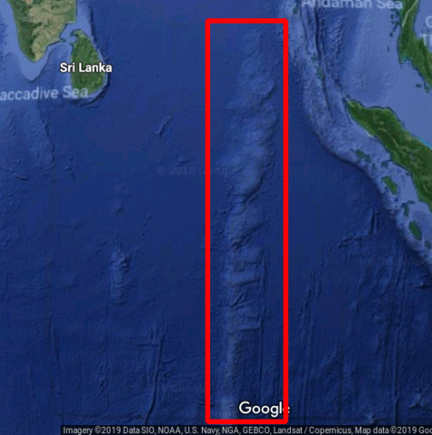
- Why is there a 3,000-mile-long, underwater ridge 1 2 in the Indian Ocean? (See Figure 1 3 )
- Why does it have a north-south orientation?
- Why is it south of and pointed toward the Himalayas?
- How did it form?
We will explore these questions in this article.
Clues
One clue is that directly north of the ridge is the most massive mountain range in the world - the Himalayas. We also note that the Tibetan Plateau is also present just north of the Himalayas. This plateau contains much elevated mass also. The average height of this plateau is 14,800 feet, and it stretches 1,600 miles east-west and 620 miles north-south. This is a lot of mass directly north of the ridge!
Conventional Explanation
Wikipedia tells us
"... [A] hotspot in the mantle beneath the Indo-Australian Plate created the ridge as the plate has moved northward..." 4
Hotspots are explained by plumes of magma rising from the mantle (the large portion of the earth that lies beneath the crust and the central core) or from shallower depths. 5
According to Wikipedia:
There are two hypotheses that attempt to explain their origins. One suggests that hotspots are due to mantle plumes that rise as thermal diapirs from the core–mantle boundary. The other hypothesis is that lithospheric extension permits the passive rising of melt from shallow depths. 5
However, there are problems with plumes, 5 as Geophysics Professor Gillian Foulger indicates in his 2010 book Plates vs Plumes: A Geological Controversy:
Since the advent of the mantle plume hypothesis in 1971, scientists have been faced with the problem that its predictions are not confirmed by observation. 6
Another Model
The model described in this article is that the ridge was caused by a rip in the crust which opened a path for magma to rise and form the ridge. The obvious questions are,
- Why would the crust rip? and
- Why would it rip in this particular location and not some other?
In this model, the crust of the earth near the ridge moved south, differently than the normal spin of the earth on its axis, which moves the earth's surface west-east, not south. Such a rare movement shifted the entire earth's crust, not just the part near this ridge.
Physics
To understand this event, let's review some physics. Spinning objects obey certain laws of physics. If there is a concentration of mass spinning about an axis, centrifugal force will "pull" that mass away from the spin axis. You may have felt this "pull" if you ever held a rope with an object attached and spun it around you, such as a cowboy does with a rope at a rodeo. This force increases the faster the mass is spun.
Due to the spinning of the earth, there is a centrifugal force outward away from the earth's spin axis. The part of the earth where this force is greatest is the part of the earth which is moving at the greatest speed and that is the farthest distance away from the spin axis. That part of the earth is the equator.
The bulge
This outward centrifugal force causes a slight bulge at the equator. This bulge is important to note; we will refer to it later.
Orogenesis
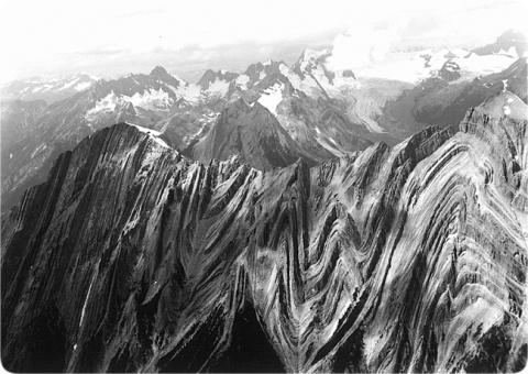
Orogenesis is the process of mountain forming. The model we are considering in this article holds that mountains were formed by upward buckling. 7 Figure 2 illustrates this. The buckling forming mountain ranges was a result of the flood of Noah in this model. We will not go into why mountains buckled up because of space limitation. The details could fill a book! But for a summary of events leading up to orogenesis, see The Hydroplate Theory and The Great Flood. 8 For more detailed information on the events leading up to orogenesis, you can refer to the book In the Beginning, by Dr. Walt Brown, 9 to Dr. Brown's website, 10 11 and to a series of videos by Bryan Nickel. 12 Another article on this is "90° East Ridge" by David Warren Mathisen. 13
During orogenesis (mountain building) mountains are formed from upward buckling due to compression of the continental plate. This upward buckling resulted in "squeezing" of additional mass into the part of the crust where the mountains formed.
Recall that centrifugal force is directed away from the spin axis. Since the Himalayas were not present before they formed (which should be obvious), the mass concentration was not present before these mountains existed, and the earth's spin was balanced or in equilibrium as any spinning object would be if left alone for a reasonable time. However, after the mountains arose, these most massive and highest mountains exerted the strongest centrifugal effect on the earth which became unbalanced. Thus, centrifugal force was trying to move those mountains outward (from the earth's spin axis) as far as possible.
Since the mountains were attached to the earth's crust, and the centrifugal force was not enough to cause the mountains to leave earth, flying out into space, the mountains were restricted in their move away from the earth's axis. So, was centrifugal force stymied? No, the entire crust of the earth could slightly roll or shift to move those mountains farther away from the spin axis, while the mountains still remained attached to the earth. Where would those mountains move to? The equator was the part of the earth that was farthest from the earth's spin axis, so the mountains could move closer to the equator - which was south of them - without having to leave the earth. But the entire earth's crust was attached to the Himalayas! The only way those mountains could approach the equator was for the entire crust to shift. And, according to this model, shift it did; that is just what happened. The entire crust of the earth moved. In which direction did the crust shift? The Himalayas moved south, but opposite the Himalayas, the crust moved north.
Please note that other newly formed mountain ranges of the crust would have also been pulled by this same centrifugal force away from the earth's spin axis. The question determining what occurred was which mountain range was being pulled by the strongest force? In this case, the recently-upward-buckled Himalayas, being the largest, would have resulted in the strongest centrifugal force.
Note, this roll would have been in a different direction (more north-south) than the spinning of the earth on its axis (west-east). It would have been a temporary motion, that lasted only until equilibrium among the forces was re-established.
The rip
However, during this temporary movement of the Himalayas south toward the equator, there was also another effect.
The crust moving into the equator experienced additional centrifugal force, due to its moving father away from the spin axis, causing that part of the crust to bulge, stretching that part of the crust. It is well-known that the earth's crust bulges at the equator due to centrifugal force. (See the section above on centrifugal force - the force increases as the distance from the spin axis increases.)
However, rock does not tend to stretch very easily! It tends to crack instead.
In summary, this theory proposes that the ridge was caused by the following events:
- Non-equatorial crust surrounding the Himalayas moving south into the equatorial area
- Other parts of the crust also moving, being dragged along, carrying regions into or out of temperate areas, tropical areas, and/or frigid areas 14
- This crust experiencing more and more centrifugal force as it moved further away from the earth's spin axis
- This crust being stretched to bulge outward, or ripped, by the centrifugal force
- The southward motion continuously occurred as movement continued; and the Himalayas moving further south, stopping only when equilibrium of forces was reached
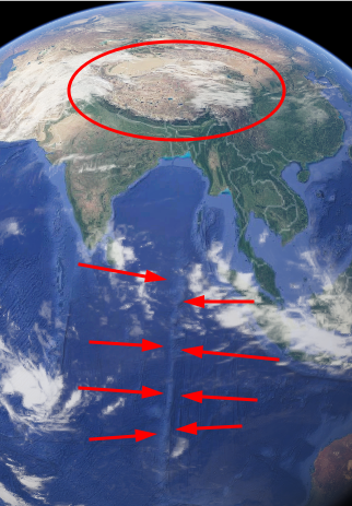
- Due to the combined effects of the crustal-tension-induced rip in the earth's crust and the continuous southward movement of the crust, there was a continuous linear rip in the direction from north to south since that was the direction of motion of the crust that was being torn apart (Fig. 3 15 )
This rip in the crust, from north to south, beneath the Himalayas, would have resulted in material from beneath bulging upward into the crack, as a pressurized inner tube of an old automobile tire bulges through a crack in the tire. This bulge is proposed to have resulted in the 90 east ridge!
You might be wondering, "Would other mountains produce similar effects tending to 'roll' the earth's crust?" There were indeed other mountain ranges, but they were less massive than the Himalayas. They would also tnd to produce a roll of the earth's crust, but the force of the most massive region would dominated the others. Yet they would have had their effect on the roll of the crust that moved the Himalayas southward; thus, the mass of other (mostly mountainous) regions on the earth that also were formed at the time of the flood would have formed a counterbalance so that the Himalayas would not roll all the way to the equator. A mechanical engineer would say the resultant force was the combined resultant of all the individual force vectors.
So we can understand that the regions of earth's crust moving into the equator region were stretching outward, bulging, while the previously "bulged" region was moving south, away from the equator, with less bulging force. The tension from this stretch would have ripped apart the crust at the place where the tension was greatest - where the bulge increase was greatest, which was south of the moving Himalayas. As the Himalayas continued to move southward, the already ripped crust moved south too, while another region moved south into the equatorial region where centrifugal force created more tension, increasing the bulge, and ultimately extending the rip. This elongated north-south rip in the crust allowed magma to escape into the rip, forming the ridge.
The result of this would have been a "stretch mark" on the crust of the earth, aligned north-south in concordance with the direction of the most extreme change in the bulge of the crust. This stretch mark would explain the 90 East Ridge.
Also, this explanation would require the ridge to be underneath or south of the mass concentration. This fits with the fact that the 90 East Ridge is directly south of the Himalayas. There is a short video about this with animation by Bryan Nickel on youtube.com. 16
Why isn't there another ridge on the opposite side of earth?
The mantle was not as heavily fractured on the opposite side of the earth, according to Hydroplate Theory. The mantle was much weaker in the Indian Ocean area. For a video with animations dealing with this issue, see https://youtu.be/QQr7ZDWdKCk?t=292.
Other Indications of a Roll of the Earth's Crust
Mammoths
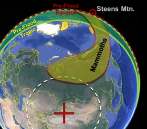
The 40-degree roll indicated by the ridge suggests to us where the previous North Pole was located, which would have been in central Asia. Locations where mammoths have been found would then have been in temperate zones, as shown in Figure 4. 17 [\fn]Spears J (2014) Mammoth Mystery https://tasc-creationscience.org/article/mammoth-mystery Accessed 2019 Jul 29
This can explain the mystery of how a mammoth could be discovered with an undigested plant in its body while the plant could not have grown in the conditions assumed for the region in which the mammoth was discovered. For more on why mammoths were rapidly frozen, see Mammoth Mystery. 18
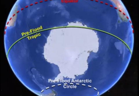
Antarctica and the Arctic would then be in much warmer zones. Antarctica then would have been largely in a temperate zone (Fig. 5). 19 This can account for what we find - trees under the ice in Antarctica, for example. 20 ,21
Magnetic orientation
Evidence at Steens Mountain in Oregon has scientists wondering how the earth's magnetic field changed so quickly - up to several degrees per day.
However, at Steens Mountain, when the field reversed 15.5 million years ago, the lava flows suggest that the field's axis was rotating 3-8° per day -- incredibly fast according to current thinking, in fact a thousand times faster than expected. 22
[T]he Steens Mountain record bears evidence of a complete magnetic reversal that occurred at an extraordinarily rapid pace (between 3 and 8 degrees per day) ... 23
Geologist Andrew Snelling says of Steens Mountain:
[T]he rate at which the orientation of the ancient geomagnetic field had rotated could have reached an astounding 6° per day over an eight-day period ... 24
However, in the scenario of this article, the magnetic field need not have changed to produce this evidence, if instead of the earth's magnetic field's orientation changing with respect to the crust, the earth's crust was moving through the earth's magnetic field! 25 Due to the roll of the earth's crust described in this article, the mountain would have had to travel through quite a bit of the earth's magnetic field.
Summary
We have described a feature of the earth whose conventional explanation has problems, and for which a model that is based on Dr. Walt Brown's Hydroplate Theory has answers. Also, we see evidence in support of this proposed model, from magnetic orientation at Steen's Mountain to trees in Antarctica. Dr. Brown's Hydroplate Theory explains the 90 East Ridge and many other real-world geological observations and is consistent with the world-wide flood mentioned in Genesis. To learn more about the Hydroplate Theory, see the references within this article to Dr. Brown's book and website.
- 1Westerman T (2015) The Ninety East Ridge. http://geoledgers.com/Africa/90East/90East.htm Accessed 2019 Jul 31
- 2Brown W (1995-2013) The Hydroplate Theory: An Overview. In the Beginning: Compelling Evidence for Creation and the Flood, Part II: Fountains of the Great Deep, Notes on Figure 44. https://www.creationscience.com/onlinebook/HydroplateOverview2.html, last edited July 23, 2019, 20:46:48
- 3Google Maps. Retrieved February 4, 2019, from https://www.google.com/maps/@-7.790219,91.9998261,7534774m/data=!3m1!1e3!5m1!1e4
- 4Wikipedia, Ninety East Ridge. https://en.wikipedia.org/w/index.php?title=Ninety_East_Ridge&oldid=855447236, last edited July 14, 2019, 06:07
- 5 a b c Wikipedia, Hotspot (geology). https://en.wikipedia.org/wiki/Hotspot_(geology), last edited July 15, 2019, 15:29
- 6Foulger GR (2010) Plates vs Plumes: A Geological Controversy, Wiley-Blackwell, Indianapolis. Available at: https://www.wiley.com/en-us/Plates+vs+Plumes%3A+A+Geological+Controversy-p-9781405161480 Accessed 2019 Jul 31
- 7hydroplateoverview-folded_mountain.jpg (650×461). (n.d.). Retrieved February 5, 2019, from http://www.creationscience.com/onlinebook/webpictures/hydroplateoverview-folded_mountain.jpg; used with permission from creationscience.com
- 8Brown W (2010) The Hydroplate Theory and The Great Flood. https://tasc-creationscience.org/article/hydroplate-theory-and-great-flood Accessed 2019 Jul 31
- 9Brown W (1995-2013) In the Beginning: Compelling Evidence for Creation and the Flood. http://www.creationscience.com/onlinebook/ Accessed 2019 Jul 30
- 10Brown W (1995-2013) https://www.creationscience.com Accessed 2019 Jul 31
- 11Brown W (1995-2013) The Hydroplate Theory: An Overview. In the Beginning: Compelling Evidence for Creation and the Flood. https://www.creationscience.com/onlinebook/HydroplateOverview2.html, last edited July 23, 2019, 20:46:48
- 12Nickel B (2016 Aug 18) Hydroplate Theory Overview (parts 1-6 combined) updated https://www.youtube.com/watch?v=4hhE6tzJR_c&list=PLpl6E8stJTiIi8wdLgYj1eXpp-4o1UUkZ Accessed 2019 Jul 30
- 13Mathisen DW (2011 Oct) 90° East Ridge. https://www.starmythworld.com/mathisencorollary/2011/10/90-east-ridge.html Accessed 2019 Jul 31
- 14This movement resulted in changes in the climate of regions such as Antarctica and Siberia.
- 15Google Maps. https://www.google.com/maps/@4.6407281,91.4596083,2669581m/data=!3m1!1e3!5m1!1e4
- 16Nickel B (2017 Sep) Hydroplate Theory: The 90 East Ridge Location (now w/ CC). https://www.youtube.com/watch?v=QQr7ZDWdKCk Accessed 2019 Jul 30
- 17Nickel B (2015 Dec) Hydroplate Theory Overview Part 5. https://youtu.be/ruvUSo-fB1s?t=1437
- 18Spears J (2014) Mammoth Mystery https://tasc-creationscience.org/article/mammoth-mystery Accessed 2019 Jul 29
- 19Nickel B (2015 Dec) Hydroplate Theory Overview Part 5. https://youtu.be/ruvUSo-fB1s?t=1456
- 20Thompson JR (2012 Sep 03) Antarctic trees surprise scientists. Earth Magazine. American Geosciences Institute. https://www.earthmagazine.org/article/antarctic-trees-surprise-scientists Accessed 2019 Jul 30
- 21Zachos E (2017 Nov 15) Antarctica Was Once Covered in Forests. We Just Found One That Fossilized. National Geographic site. https://news.nationalgeographic.com/2017/11/ancient-fossil-forest-found-antarctica-gondwana-spd/
- 22The Steens Mountain Conundrum. (1992 Mar-Apr) Science Frontiers ONLINE, https://www.science-frontiers.com/sf080/sf080g13.htm Accessed 2019 Jul 31
- 23Garlinghouse T (2018 Dec 11) The complex history of Earth’s magnetic reversals. https://phys.org/news/2018-12-complex-history-earth-magnetic-reversals.html Accessed 2019 Jul 31
- 24Snelling, AA (2015 Jan 08) More Evidence of Rapid Geomagnetic Reversals Confirm a Young Earth. https://answersingenesis.org/age-of-the-earth/more-evidence-rapid-geomagnetic-reversals-confirm-young-earth/ Accessed 2019 Jul 31
- 25Nickel, B (2015 Dec 31) Hydroplate Theory Overview Part 5, https://youtu.be/ruvUSo-fB1s?t=1098 Accessed 2019 Jul 31
